Blog, Business, History, Info, Forum, Classified, Photo Album
FREE business/organization listing. Submit your promotional statement (pictures). Your business will be featured for FREE [more]
Ventura County community website created and maintained by your Ventura County neighbor |
Blog, Business, History, Info, Forum, Classified, Photo Album FREE business/organization listing. Submit your promotional statement (pictures). Your business will be featured for FREE [more] |
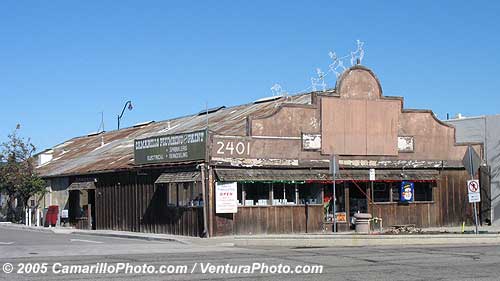
Camarillo Plumbing and Paint is one of Camarillo's landmarks.
It was originally built as a garage for Lewis family (Lewis Road is named after them). This must be one of the oldest store buildings in Camarillo. They are the key component in Old Town Camarillo's Halloween activities.
Camarillo Plumbing and Paint
2401 E. Ventura Blvd. Camarillo, CA 93010
805-482-8963 Fax: 805-987-9564
http://www.camarilloplumbing.com/

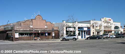
The building next to Camarillo Plumbing is also a landmark. It's been remodeled, but the basic "feeling" is there. We used to have movie theater and department store there.

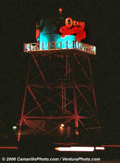
Picture was taken December 17, 2001, before the face-lift. Now, we have a totally different looking tower there.

History of Ventura County
Prior to the arrival of Europeans in California, the area was home to the Chumash tribe of Native Americans.
History of Spanish period
In October 1542, the expedition led by Juan Rodríguez Cabrillo anchored in an inlet near Point Mugu; its members were the first Europeans to arrive in the area that would become Ventura County.
Active occupation of California by Spain began in 1769. Gaspar de Portolà led a military expedition by land from San Diego to Monterey, passing through Ventura County in August of that year. A priest with the expedition, Father Juan Crespi, kept a journal of the trip and noted that the area was ideal for a mission to be established and it was a "good site to which nothing is lacking". Also on this expedition was Father Junípero Serra, who later founded a mission on this site.
On March 31, 1782, the Mission San Buenaventura was founded by Father Serra, named after Saint Bonaventure. Buenaventura is composed of two Spanish words, buena meaning "good" and ventura meaning "fortune." The town that grew up around the mission is named San Buenaventura, which came to be known as Ventura.
In the 1790s, the Spanish Governor of California began granting land rights to Spanish Californians, often retiring soldiers. These grants were known as ranchos and consisted of thousands of acres of land that were used primarily as ranch land for livestock. By 1822, there were 19 rancho grants in Ventura County.
History of Mexican period
In 1822, California was notified of Mexico's independence from Spain and the Governor of California, the Junta, the military in Monterey and the priests and neophytes at Mission San Buenaventura swore allegiance to Mexico on April 11, 1822. California land that had been vested in the King of Spain was now owned by the nation of Mexico. By the 1830s, Mission San Buenaventura was in a decline with fewer neophytes joining the mission. The number of cattle owned by the mission dropped from first to fifteenth ranking in the California Missions.
In 1836, Mission San Buenaventura was transferred from the Church to a secular administrator. The natives who had been working at the mission gradually left to work on the ranchos. By 1839, only 300 Indians were left at the Mission and it slipped into neglect.
Several outhouses were discovered in July 2007 dating back to the 1800s. They have proved to be a treasure trove for archaeologists who braved the lingering smell in the dirt to uncover some 19th Century artifacts.
Hostory of United States of America period
The Mexican–American War began in 1846 but its effect was not felt in Ventura County until 1847. In January of that year, Captain John C. Frémont led the California Battalion into San Buenaventura finding that the Europeans had fled leaving only the Indians in the Mission. The Fremont and the Battalion continued south to sign the Treaty of Cahuenga with General Andrés Pico. The Treaty of Guadalupe Hidalgo formally transferred California to the United States in 1848.
By 1849, a constitution had been adopted for the California territory. The new Legislature met and divided the pending state into 27 counties. At the time, the area that would become Ventura County was the southern part of Santa Barbara County.
The 1860s brought many changes to the area. A drought caused many of the ranchos to experience financial difficulties and most were divided, sub-divided and sold. Large sections of land were bought by eastern capitalists based on favorable reports of petroleum deposits. A United States Post Office was opened at Mission San Buenaventura in 1861. On April 1, 1866, the town of San Buenaventura was incorporated becoming the first officially recognized town in Ventura County.
On January 1, 1873, Ventura County was officially split from Santa Barbara County, bringing a flurry of change. That same year, a courthouse and wharf were built in San Buenaventura. A bank was opened and the first public library was created. The school system grew, with the first high school opening in 1890.
Other towns were starting in the county. A plan for Port Hueneme was recorded in 1874, and Santa Paula's plan was recorded in 1875. The community of Nordhoff (later renamed Ojai) was started in 1874. Piru, Fillmore and Montalvo were established in 1887. 1892 saw Simi (later Simi Valley), Somis, Saticoy and Moorpark. Oxnard was a late-comer, not being established until 1898.
The Southern Pacific Railroad laid tracks through San Buenaventura in 1887. For convenience in printing their timetables, Southern Pacific shortened San Buenaventura to Ventura. The Post Office soon followed suit. While the city remains officially known as San Buenaventura, it is more commonly referred to as Ventura.
It had been known that oil existed in Ventura County as far back as the Chumash people, who used tar to make baskets and canoes waterproof. In the 1860s, several attempts were made to harvest the petroleum products under Ventura County but none were financially successful, and the oil speculators eventually changed from oil to land development. In 1913, oil exploration began in earnest, with Ralph Lloyd obtaining the financial support of veteran oil man Joseph B. Dabney. Their first well, named "Lloyd No. 1", was started on January 20, 1914. The well struck oil at 2558 feet (780 m) but was destroyed when it went wild. Other wells met a similar fate, until 1916, when a deal was struck with the Shell Oil Company. Other deals followed with General Petroleum in 1917 and Associated Oil Company in 1920. At its peak, the Ventura Avenue oilfield was producing 90,000 barrels of oil a day, with annual production of over a million and a half barrels.
In the early hours of the morning of March 13, 1928, the St. Francis Dam collapsed, sending billions of gallons of water rushing through the Santa Clara Valley, killing 385 people, destroying 1,240 homes and flooding 7,900 acres (32 km²) of land, devastating farm fields and orchards. This was the largest single disaster to strike Ventura County.
Modern period
Ventura County can be separated into two major parts, East County and West County. East County consists of all cities east of the Conejo Grade, known locally as "The Grade." East County, geographically, is the end of the Santa Monica Mountains, in which the Conejo Valley is located, and where there is a considerable decrease in elevation. Communities which are considered to be in the East County are Thousand Oaks, Newbury Park, Lake Sherwood, Hidden Valley, Santa Rosa Valley, Oak Park, Moorpark, and Simi Valley. A majority of these communities are in the Conejo Valley, one of the most affluent areas in the United States. West County, which is everything west of the Conejo Grade, consists of communities such as Camarillo, Oxnard, Somis, Point Mugu, Port Hueneme, Ventura, Ojai, Santa Paula, and Fillmore. West County consists of some of the first developed cities in Ventura County. Ventura County's largest beach communities are located in West County on the coastline of the Channel Islands Harbor.
- Ventura County History -
Camarillo is named for Adolfo Camarillo, one of the few Californios (pre-1851 California natives of Spanish ancestry) to retain his holdings after the arrival of Anglo settlers. As with most cities in Ventura County, it is noted for its resistance to urban sprawl. Some of the most desirable land in the city limits, located on the north and south sides of the Ventura Freeway, is permanently zoned for agricultural use. Recently, however, the city has seen a great deal of growth that has been decried by area residents as environmentally destructive and not well enough planned. It is also home to the Ventura County, California Sheriff's Department Academy.
The Chumash Indians were the first known settlers in what is now known as Ventura County. Fishermen, they built their villages along the Pacific Coast near the mouths of the Calleguas Creek and Santa Clara River. Artifacts from their settlements are on display in the Ventura County Historical Museum and their paintings are still visible on canyon walls and in caves in the area.
The Portugues navigator Juan Cabrillo, while exploring the Pacific coast for the king of Spain, came upon the Chumash in an area near Point Mugu. He explored the surrounding region and claimed it in the name of Spain in 1542. Cabrillo was followed in 1602 by Sebastian Viscaino on a mapping expedition for the King of Spain. The Chumash continued to inhabit the coast until 1768 when Russians, having established a settlement 800 miles to the north, launched expeditions challenging the Spanish land claims. In the 1700s the Spanish began settling California and built the first of what would become a chain of 21 missions in San Diego. Father Junípero Serra establish the ninth mission in Ventura in 1782 bringing more settlers to the area and exposing the Indians who had settled around the mission to many European diseases to which they had no immunity. Their numbers diminished until the Chumash, once the largest Indian nation in California, had largely vanished by 1839.
By the early 1820s, Mexico had gained independence from Spain and shortly afterward California allied itself with Mexico. The Mexican land grant system was liberalized in 1824 resulting in many large grants in California and the proliferation of Ranchos north of the border. One grant to Jose Ruis created the Rancho Calleguas in 1847, in the area that is now Camarillo. The grant was later sold to Juan Camarillo and it was his sons, Adolfo and Juan, who are credited with the founding of the town that was to bear their name. The earlier proposed name of Calleguas was rejected as too difficult to pronounce.
At about same time the town of Springville had begun to form just to the west of the emerging town of Camarillo but when the Southern Pacific railroad was built and chose Camarillo as the location for a depot, Springville's existence was threatened. It is now only a dot on the map in an area south of the freeway at the western end of he current Camarillo city limits.
Camarillo's growth was slow from founding through World War II. In the late 1940s building lots on Ventura Boulevard, the main downtown street, were being offered for $450 and home lots on the adjoining streets were $250, with few buyers. Travel to and from Los Angeles was difficult, owing to the narrow, tortuous road climbing the Conejo Grade to the east of the city.
The main industry during this period was agriculture, and the area surrounding the small town was blanketed with orange, lemon and walnut groves. The State Mental hospital south of the town was the largest employer. A few houses had sprung up to the north and south of town center. The Oxnard Airforce Base, built during WWII to the west of town, the Navy Facility at Point Mugu and the Seabee base at Port Hueneme brought many service personnel to the area, but there was little private industry or other sources of non-agricultural employment.
In the middle 1950s the Ventura Freeway, which bisected the town, was completed from L.A. to points north making it an easy one hour trip to Camarillo. The freeway was originally planned to follow the path of Potrero Road, south of Camarillo, which would have competely by-passed the soon to be city. However, after much debate, "city officials" persuaded Cal Trans to lay the freeway parallel to Ventura Blvd, creating the infamously steep decent from the Santa Monica Mountain Range, known as the Conejo Grade. The completion of the freeway facilitated the growth that followed. In 1962 the population was 7500 and 3M began construction for the Mincom and Magnetic Tape Divisions, which would ultimately employ 900 people, becoming the largest local employer. Housing tracts were built where orchards once stood. House prices were $14,000 to $65,000.
At this time plans were made for the incorporation of the city in to control the rapid expansion. Camarillo became a city in 1964 and soon put into place a General Plan and building codes that were to lead to an attractive city environment. In 1964 the closest traffic signal was 2 miles from the City center on the road to Point Mugu, and the first shopping center and supermarket were under construction. Much of the city was expected to be developed to the south of Ventura Blvd, however it was to the north that the new city grew, and the land south of Ventura Blvd remains reserved for agricultural use to this day.
Many of the home buyers during the 1960s were from the military veterans, who had been stationed at one of the local bases during their service. The temperate climate and the living conditions lured them back. With the establishment of both the Pacific Missile Range and the Naval Civil Engineering Laboratory at Port Hueneme many found employment that utilized their military training. Other newcomers were those who worked and lived in the San Fernando Valley and were willing to endure the commute for the opportunity to raise their families in a smog-free, semirural environment. Still others relocated here with their employers, like 3M, who were now building facilities in and around the city to take advantage of the large workforce.
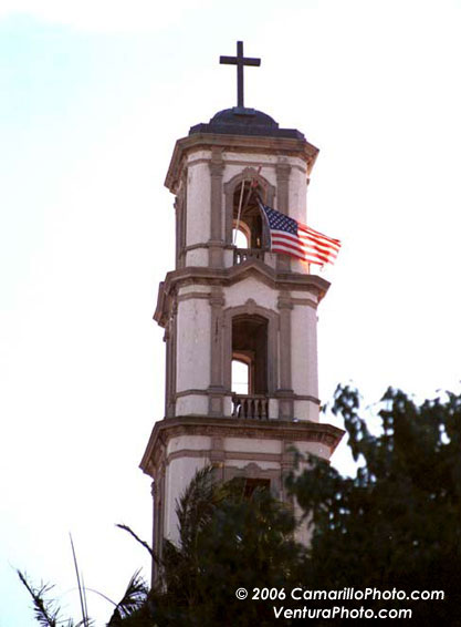
St Mary Magdalen right after 911.
I thought this was very unusual.
Churches don't usually make political statements.
At that time, American flag meant "I hate you, Bin Laden".
It also meant "If you are against us, you can kiss my behind"

Section Menu