![]()
We Love Ventura County
Blog, Business, History, Info, Forum, Classified, Photo Album
FREE business/organization listing. Submit your promotional statement (pictures). Your business will be featured for FREE [more]
Ventura County community website created and maintained by your Ventura County neighbor |
Blog, Business, History, Info, Forum, Classified, Photo Album FREE business/organization listing. Submit your promotional statement (pictures). Your business will be featured for FREE [more] |
I have a new blog. I also have a facebook page I am doing well. I still do photography & web design here in Ventura County. Thank you |
 Ventura, California
 Incorporated in 1866, the city of San Buenaventura (usually referred to as Ventura) is the county seat of Ventura County, California. Ventura has a population of 105,000. Ventura is accessible via U.S. Route 101, California State Route 33, and California State Route 126.
History
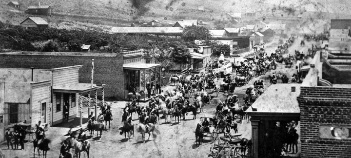
A July 4, 1874 celebration in Ventura, California. Marshall of the parade was Thomas R. Bard.
Father Junípero Serra founded Mission San Buenaventura in 1782[1], forming the basis of what would become the city. On July 6, 1841, Governor Juan Bautista Alvarado granted the 48,611 acre (19,672 ha) Rancho San Miguel to Felipe Lorenzana and Raimundo Olivas[2], whose Olivas Adobe on the banks of the Santa Clara River was the most magnificent hacienda south of Monterey.
After the American Civil War, settlers came to the area, buying land from the Mexicans, or simply as squatters. Vast holdings were later acquired by Easterners, including the railroad magnate, Thomas Scott. He was impressed by one of the young employees, Thomas R. Bard, who had been in charge of train supplies to Union troops, and Bard was sent west to handle Scott's property.
Not easily accessible, Ventura was not a target of immigrants, and as such, remained quiet and rural. For most of the century which followed the incorporation of Ventura in 1866, it remained isolated from the rest of the state.
Bard is often regarded as the Father of Ventura and his descendants have been prominently identified with the growth of Ventura County. The Union Oil Company was organized with Bard as President in 1890, and has offices in Santa Paula. The main Ventura oil field was drilled in 1914 and at its peak produced 90,000 barrels a day. The city is located between the Ventura River and the Santa Clara River, leading to soil so fertile that citrus grew better here than anywhere else in the state. The citrus farmers formed Sunkist Growers, Incorporated, the world's largest organization of citrus production.
From the south, travel by auto was slow and hazardous, until the completion of a four-lane expressway (US Highway 101) over the Conejo Grade in 1959. This route, now further widened and improved by 1969, is known as the Ventura Freeway, which directly links Ventura with the Los Angeles metropolitan area. Another route, US Highway 101 ALT (now the Pacific Coast Highway) traveled along the coast from Santa Monica via Oxnard, but was not heavily used.
From the north, entrance was by way of a single road along the beach and stagecoach passengers either had to wait until low tide when the horses could cross on the exposed wet sand, or go up the Ventura River Valley and then cross over the mountains to Santa Barbara via Casitas Pass, a long and difficult trip.
Inland, Ventura was hemmed in by (what is now) the Los Padres National Forest, composed of mountainous country and deep canyons. This route became passable with the completion of the Maricopa Highway in the 1920s.
Since then, Ventura has grown steadily. In 1920 there were 4,156 people. In 1930 the population had increased to 11,603, and by 1950 the population reached 16,643. In the last two decades it has quadrupled to approximately 105,000.
| City of San Buenaventura, California | |
| Coordinates: 34°16′30″N, 119°13′40″W | |
|---|---|
| Country | United States |
| State | California |
| County | Ventura |
| - Mayor | Carl Morehouse |
| Area | |
| - City | 84.6 km² |
| - Land | 54.6 km² |
| - Water | 30.0 km² |
| Population (2006) | |
| - City | 105,000 |
| - Density | 1,849.3/km² |
| Time zone | PST (UTC-8) |
| - Summer (DST) | PDT (UTC-7) |
| Website: http://www.ci.ventura.ca.us/ | |
-
Mission San Buenaventura
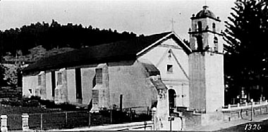
San Buenaventura circa 1900. Photograph by William Amos Haines
Mission San Buenaventura (originally), the was founded on Easter Sunday, 1782. Named for a Franciscan theologian, it was the last of the missions founded by Father Serra. In 1793, the first church burned down. It took the neophyte workers 16 years to build the new church, which still stands today. Mission San Buenaventura had five bells. The bells were borrowed from Mission Santa Barbara because there were no bells at the time. The bells were never returned. The bell facing north is labeled S. San Francisco 1781. The bell facing east has the inscription: San Pedro Alcantra 1781. A small swinging bell hangs in the southern arch with the lettering: Ave Maria S. Joseph. The only bell used daily at San Buenaventura is large and crown topped with a Cross on its side. Inscribed on the bell is Ave Maria Pruysyma D Sapoyan Ano D 1825, which means Hail Mary Most Pure. Mary of Zapopan Year of 1825. This bell was originally cast for the church of Zapopan but was later sent to Mission San Buenaventura. Another bell, which was once the gift of the Spanish Viceroy, is inscribed Marquez de Croix Mexico November 12 1770. It is currently owned by Senora Isabel del Valle Cram. There are also two wooden bells in the museum that measure about two feet. A system of aqueducts was built by Chumash Indians between 1805–1815 to meet the needs of the Mission population and consisted of both ditches and elevated stone masonry. The watercourse ran from a point on the Ventura River about ½ mile north of the remaining ruins and carried the water to holding tanks behind the San Buenaventura Mission, a total of about 7 miles. The entire water distributiom system was destroyed by floods and abandoned in 1862. In 1893, Father Cyprian Rubio "modernized" the interior of the church, painting over the original artwork; when he finished, almost nothing remained of the old church. New priests restored the church to its original style in 1957.
Today all that remains of the original Mission is the church and its garden. Services are still held in the parish church. A small museum sits at the Mission with displays of Chumash Indian artifacts and mission-era items.
Other historic designations
| Location | Ventura, California |
|---|---|
| Name as Founded | La Misión San Buenaventura |
| Translation | The Mission of Saint Bonaventure |
| Namesake | Saint Bonaventure |
| Nickname(s) | "The Mission by the Sea" |
| Founding Date | March 31, 1782 |
| Founding Priest(s) | Father Presidente Junípero Serra |
| Founding Order | Ninth |
| Military District | Second |
| Native Tribe(s) Spanish Name(s) | Ventureño |
| Owner | Roman Catholic Church |
| Current Use | Parish Church / Museum |
| National Historic Landmark | #NPS–75000496 |
| California Historical Landmark | #310 |
| Web Site | sanbuenaventuramission.org |
-
Section Menu