![]()
We Love Ventura County
Blog, Business, History, Info, Forum, Classified, Photo Album
FREE business/organization listing. Submit your promotional statement (pictures). Your business will be featured for FREE [more]
Ventura County community website created and maintained by your Ventura County neighbor |
Blog, Business, History, Info, Forum, Classified, Photo Album FREE business/organization listing. Submit your promotional statement (pictures). Your business will be featured for FREE [more] |
I have a new blog. I also have a facebook page I am doing well. I still do photography & web design here in Ventura County. Thank you |
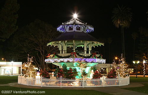
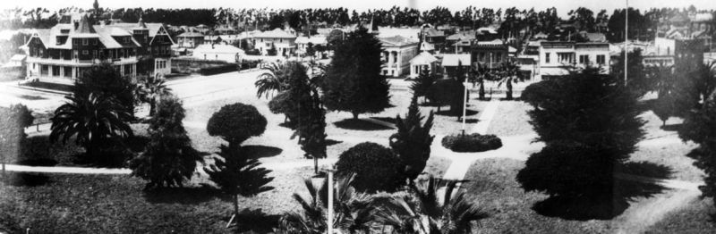
Oxnard Pagoda (AKA Bandstand) is owned by the City of Oxnard.
It's located at 300 W Third St, Oxnard California, 93030
Click here for pictures of Oxnard Plaza Park
The plaza park was built in 1898 by Colonia Improvement Company as a part of the Oxnard town-site. City of Oxnard purchased the park in 1908 and hired William David Cook to design a new landscape for Plaza Park.
Cook's plan included a Pagoda with a tile roof. Architect Alfred Priest and contractor Thomas Carroll constructed a pagoda with water feature. Plaza Pagoda was completed 1910. At that time the Pagoda was shorter. We don't know the exact reason why they chose Asian style pagoda.
Bandstand:
Oxnard had a band at that time. City of Oxnard wanted to support their band by providing a bandstand at the pagoda. City of Oxnard called back the same architect and contractor to raise the roof so the band can play music under the roof.
Alfred Priest:
Alfred Priest was born in Nebraska (1888) and moved to Los Angeles when he was 18 years old. He resided in Glendale and designed many houses, schools, businesses, and clubhouses around Los Angles and Ventura County.
In 1971, the Pagoda was designated as Ventura County Landmark No. 17. The entire Plaza Park is a strong candidate to become a registered historic location.
The pagoda was restored in the 1990s.
-
NO. 113 SITE OF JUNÍPERO SERRA'S CROSS
the first cross on the hill known as La Loma de la Cruz, or the "Hill of the Cross") can be found in Grant Park, and was erected by Junípero Serra upon the Mission's founding
Location: Grant Park, at end of Ferro Dr, Ventura
NO. 114 OLD MISSION RESERVOIR
part of the water system for Mission San Buenaventura (the settling tank or receiving reservoir; the site can be found in Eastwood Park)
Location: Eastwood Park, N of Valdez Alley, 115 E Main St, Ventura
Listed on the National Register of Historic Places: NPS-75000496
NO. 114-1 SAN BUENAVENTURA MISSION AQUEDUCT
(at Canada Larga Road) consists of two surviving sections of viaduct about 100 feet long, made of cobblestone and mortar
Location: 234 Canada Larga Rd, Ventura
Listed on the National Register of Historic Places: NPS-75000497
NO. 115 OLIVAS ADOBE
The Olivas Adobe, located in Ventura, California, is an adobe built in 1837 by Don Raymundo Olivas.
Olivas received approximately 2,250 acres (9 km²) as part of land grant from Governor Juan Bautista Alvarado, which he named Rancho San Miguel, in recognition of his service at the Presidio of Santa Barbara. The land had originally been part of Mission San Buenaventura, but was appropriated during the secularization of the missions.
He expanded the building in 1849 to two stories, making it the only such building in the area. He and wife and their 21 children lived here until 1899. It later became part of Max Fleischman's holdings (of yeast and margarine fame), and it was he who donated the land and the house to the City of Ventura.
The adobe is rumored to be haunted by a woman ghost and is listed as one of Ventura County's few haunted locations.
Location: 4200 Olivas Park, Ventura
Listed on the National Register of Historic Places: NPS-79000570
NO. 310 MISSION SAN BUENAVENTURA
Mission San Buenaventura was founded on Easter Sunday, 1782. Named for a Franciscan theologian, Saint Bonaventure, it was the last of the missions founded by Father Serra. Mission San Buenaventura was supposed to be founded in the year 1770, but the founding was delayed because of the low availability of the military escorts needed to establish Mission San Buenaventura. In 1793, the first church burned down. It took the neophyte workers 16 years to build the new church, which still stands today.
Location: 210 E Main St at Figueroa, Ventura
Listed on the National Register of Historic Places: NPS-75000496
NO. 553 RANCHO CAMULOS
Location: On State Hwy 126 (P.M. 30.6), 2.2 mi E of Piru
Listed on the National Register of Historic Places: NPS-96001137
NO. 624 WARRING PARK
Location: Warring Park, 700 block of Orchard St, Piru
NO. 659 STAGECOACH INN
Located in Newbury Park, California, the Stagecoach Inn (also known as the Grand Union Hotel) was used as a resting area for people who traveled from Los Angeles to Santa Barbara. It is California Historical Landmark no. 659 and is listed in the National Register of Historic Places (NPS-75000495).
Originally located some 200 yards to the north of its present location, the inn was built in 1876. Its redwood lumber came by sea and was freighted up the steep Conejo Grade (between Thousand Oaks and Camarillo) by multiteam wagons. From 1887 to 1901, the hotel served as a regular depot for the Coast Stage Line, which carried both passengers and mail. In the 1960s, the hotel was threatened with demolition by the expansion of the Ventura Freeway, but it was granted Historical Landmark status and moved to its present location.
In April, 1970, a fire entirely destroyed the museum and its contents. Although the reconstructed museum was dedicated and opened on July 4, 1976, the second floor was not completed until 1980.
Today, the inn consists of the museum, a replica of Timber School (originally built in 1889), the carriage house and blacksmith shop, a nature trail, and the 'Tri-Village', a small group of three houses: the pioneer house, the adobe, and the Chumash village. There is also a gift shop located inside the museum. Volunteers operate the museum, although it is run by the Conejo Valley Historical Society. There is also a Jr. Docent program for children and teenagers aged 8-18.
The Stagecoach Inn is open Wednesday through Sunday, from 1-4 pm., in Newbury Park.
Location: 51 S Ventu Park Rd, Newbury Park
Listed on the National Register of Historic Places: NPS-75000495
NO. 727 PORTOLÁ EXPEDITION
Location: Santa Paula Boys Club Recreation Center, 1400 block of Harvard Blvd, Santa Paula
NO. 756 SYCAMORE TREE
Location: On State Hwy 126 (P.M. 16.7) at Hall Rd, 4 mi E of Santa Paula
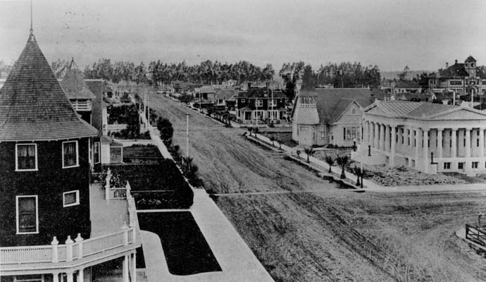
NO. 847 VENTURA COUNTY COURTHOUSE
The Ventura County Courthouse, located in Ventura, California, was designed in 1910 by one of the early pioneers of architecture in Southern California: Albert C. Martin, Sr. Dedicated in July 1913, the structure is an outstanding example of neo-classical architecture, a style prevalent in the United States at the turn of the century. The courthouse is an extremely well-proportioned building, and is rich in detail and materials not likely to be found elsewhere in the Southern California area. It is registered as California Historical Landmark #847 and listed on the National Register of Historic Places (NPS-71000211). It now serves as the Ventura City Hall
Location: 501 Poli St. at N California St, Ventura
Listed on the National Register of Historic Places: NPS-71000211
NO. 939 Twentieth Century Folk Art Environments (Thematic)-GRANDMA PRISBREY'S BOTTLE VILLAGE
Location: 4595 Cochran St, Simi Valley
NO. 979 RANCHO SIMI
Rancho San José de Nuestra Senora de Altagarcia y Simi is one of the land grants in California by the Spanish government. The name derives from Shimiji, the name of the Chumash village here before the Spanish. At 113,000 acres (45,730 ha), Rancho Simi was one of the state's largest land grants. Two prominent Spanish and Mexican family names are connected with the Rancho: Santiago Pico who first received the grant, and José de la Guerra who purchased the Rancho in 1842.
The headquarters of the rancho served as the home of Robert P. Strathearn (and are thus known as the Strathearn House), built in 1892–93. The home remained in the Strathearn family until 1969, when the dwelling and 5.85 acres (2.37 ha) of surrounding land were donated to the Simi Valley Recreation and Park District. Two rooms of original adobe remain, now located in Robert P. Strathearn Historical Park in Simi Valley, California, which have been designated a California Historical Landmark (#979) and are listed on the National Register of Historic Places.
Location: Robert P Strathearn Historical Park, 137 Strathearn Place, Simi Valley
Listed on the National Register of Historic Places: NPS-78000825
NO. 996 UNION OIL COMPANY BUILDING
The Santa Paula Hardware Company Building, located in Santa Paula, California and more commonly referred to as the Union Oil Company Building, is significant for its historical importance as the birthplace of the Union Oil Company on October 17, 1890. The building continued to serve as a field division office after the main headquarters moved to Los Angeles in 1900. In 1950 the Union Oil Museum was established and in 1990, for its Centennial Celebration, the building was restored to its original appearance and reopened as a new state-of-the-art oil museum.
Location: 1003 E Main St, Santa Paula
Listed on the National Register of Historic Places: NPS-86002619
History of Oxnard
 Before the arrival of Europeans, the area that is now Oxnard was inhabited by Chumash Indians. The first European to encounter the area was Portuguese explorer Juan Rodriguez Cabrillo, who claimed it for Spain in 1542. During the mission period, it was serviced by the Mission San Buenaventura, established in 1782.
Ranching began to take hold among Californio settlers, who lost their regional influence when California became a U.S. state in 1850. At about the same time, the area was settled by American farmers, who cultivated barley and lima beans
 Henry Oxnard, who operated a successful sugar beet factory with his three brothers (Ben, James, and Robert) in Chino, California, was enticed to build a two-million dollar factory on the plain inland from Port Hueneme shortly after the 1897 beet campaign, a new town soon emerged. Ironically the Oxnard brothers never lived in their namesake city, and they sold both the Chino and the giant red-brick Oxnard factory with its landmark twin smokestacks in 1899 for nearly four-million dollars. The Oxnard factory operated from August 19, 1899 until October 26, 1959. Given the growth of the town of Oxnard, in the spring of 1898, a railroad station was built to service the plant, which attracted a population of Chinese, Japanese, and Mexican laborers and enough commerce to merit the designation of a town. Oxnard intended to name the settlement after the Greek word for "sugar", but frustrated by bureaucracy, named it after himself.
 Oxnard was incorporated as a California city on June 30,1903, and the public library was opened in 1907, one of only three built west of the Mississippi river financed by Andrew Carnegie. Prior to and during World War II, the naval bases of Point Mugu and Port Hueneme were established in the area to take advantage of the only major navigable port on California's coast between the Port of Los Angeles and San Francisco Bay, and these encouraged the development of the defense-based aerospace and communications industries.
In the mid-century Oxnard grew and developed the areas outside the downtown with homes, industry, retail, and a new harbor named Channel Islands Harbor. Martin V. ("Bud") Smith (1916-2001) became the most influential developer in the history of Oxnard during this time. Smith's first enterprise in 1941 was the Colonial House Restaurant (demolished 1988) and then the Wagon Wheel Junction in 1947. He was also involved in the development of the high-rise towers at the Topa Financial Plaza, the Channel Islands Harbor, Casa Sirena Resort, the Esplanade Shopping Mall, Fisherman's Wharf, the Carriage Square Shopping Center, the Maritime Museum, and a plethora of hotel and restaurant projects.
During the 1950s, a phenomenon know as white flight was commonplace in Southern California, and Oxnard was no exception. With the rise of the local defense industry and other high tech and financial industries, the more educated, predominantly Caucasian and Asian-American "white-collar" professional class moved from the older city core to the newer, more suburban neighborhoods either to the north, south, or west. Subsequently, the less educated, predominantly Hispanic and African American "blue-collar" working class populated the more affordable areas in the city center, particularly the La Colonia Barrio just east of Downtown Oxnard. The poverty and neglect in these neighborhoods gave rise to gangs such as the infamous "Colonia Chiques," and violence continues to this day over turf disputes between rival gangs.
-
Section Menu